.png)

The Himalayas Need an Accord Beyond Geopolitics, and the Alpine Convention Can Show the Way
A dedicated Himalayan Convention, even if not legally binding like the Alpine Convention, needs to be decoupled from geopolitical rivalries because avalanches and floods do not respect boundary lines.

Prakash Nanda is a veteran editor, author and strategic-affairs commentator with over three decades in media, academia and policy consulting.
September 16, 2026 at 7:11 AM IST
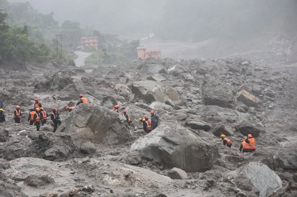
There may be various theories explaining the tragic and terrifying Himalayan flash flood on August 26 at the Nepal- Tibet (China) border that claimed more than 1,400 lives, with nearly 6,000 people still missing, and 1.6 million badly affected.
Scientists are not sure whether a chunk of mountain that collapsed into a narrow gorge, sending a tsunami of mud and rock that gathered mass as it shot down the steep Trisuli River valley, was due to a breakaway hanging glacier taking a rock face with it, or was it the other way round - a portion of rock breaking down first, and then taking down with it a large glacier.
Therefore, experts find it debatable when Nepal demands that the international community, particularly the US, China, and India, the three largest emitters of greenhouse gases, must compensate the country because the Himalayas are melting due to the global warming caused by them.
Beijing strongly denies the other theories that Chinese mega-infrastructure, hill-cutting near Gyirong, or the collapse of an artificial or "geological disaster dam" in Tibet caused the surge. It labels the accusations as fake news and maintains that the catastrophe originated from a natural seismic/glacier collapse affecting both sides of the border.
However, what is obvious, and nobody contests this, is that any catastrophe and its impacts in the Himalayas are not confined to the man-made territorial boundaries of the countries in the region. The Himalayas operate as a single ecological system. Therefore, the time for reactive, fragmented national strategies is over. The need of the hour is an integrated regional framework to confront the Himalayan challenges by overcoming the inherent geopolitical constraints.
The ecosystem of the Himalayas is not the only one that is vulnerable to mountain landslides, glacial lake outburst floods, and global warming. There are also the Andes in South America and the Alps in Europe that witness periodic rockfalls, slope failures, mudflows, and floods. But unlike the Himalayas, they have regional arrangements based on agreements among the regional countries for coordinated measures to prevent and manage disasters.
The Alpine Example
In 1991, eight Alpine states — Austria, France, Germany, Italy, Liechtenstein, Monaco, Slovenia, and Switzerland — plus the EU signed the Alpine Convention. It entered into force in 1995. It is a legally binding architecture, laying down principles (the precautionary principle being “polluter pays”) and intersectoral integration measures. There are eight binding protocols on mountain farming, mountain forests, tourism, transport, energy, soil conservation, spatial planning, and nature protection.
The Alpine Convention makes it clear that the Alps is one geographical unit, not eight fragmented sovereignties. It ensures that the eight parties inform each other of planned legal or economic measures that have particular effects on the Alpine region, share data, harmonise monitoring, and keep the public informed.
In other words, it provides a comprehensive blueprint for mountain governance by combining environmental protection with sustainable regional development. It works because it institutionalised what was already there — trust among EU partners — into law.
The South American AMI
There is no legally binding international treaty for the Andes like the Alpine Convention. However, the seven South American nations -Argentina, Bolivia, Chile, Colombia, Ecuador, Peru, and Venezuela - that are crossed by the Andes, which is the longest continental mountain range in the world, have built an alternative voluntary cooperation framework called the Andean Mountain Initiative (AMI) to achieve similar goals.
The AMI focuses on joint projects and joint declarations about conservation of biodiversity, climate change adaptation, and reducing poverty in high-mountain communities.
In fact, even though they are structured differently, the Andes and the Alps actively work together. Through global programmes like “the Adaptation at Altitude Programme”, delegates from the Andean Mountain Initiative regularly participate in “knowledge-exchange study trips” with the Alpine Convention and Carpathian convention (another international treaty aimed at the protection and sustainable development of the Carpathian Mountain region in Central and Eastern Europe covering seven countries of the Czech Republic, Hungary, Poland, Romania, Serbia, the Slovak Republic, and Ukraine) to share policies on managing climate-induced hazards like landslides and glacier retreat.
Such arrangements have shown that by translating broad ecological goals into actionable, sector-specific mandates, nations can ensure that mountain safety takes precedence over short-term economic or political gains.
Himalayan Challenge
In contrast, eight countries sharing the Himalayas - Afghanistan, Bangladesh, Bhutan, China, India, Myanmar, Nepal, Pakistan - have no such framework. The only informal body they share is the Kathmandu-based International Centre for Integrated Mountain Development (ICIMOD).
While ICIMOD excels at producing high-quality scientific assessments—such as tracking the doubling rate of ice loss since 2000—it lacks the teeth to influence national policies, enforce land-use zones, or compel cross-border data sharing.
Instead, what one sees in the Himalayas are bilateral treaties on rivers that stop at borders, dam designs cleared by one country with zero consultation on downstream floods in another, roads and diversions built upstream without regard for cross-border consequences, and the accountability for disasters getting conveniently shifted. Each country here has an isolated and self-specific disaster management, though in the interconnected Himalayan ecosystem this is an exercise in futility. Because upstream structural failures inevitably become downstream humanitarian crises.
For instance, driven by economic ambitions, countries have aggressively pursued a "hydropower-first" strategy. Nepal nearly doubled its generation to 11 Terawatt-hours by 2024, heavily exporting surplus power to India. However, building cascades of run-of-the-river dams without factoring in changing mountain dynamics creates highly vulnerable targets. The recent floods have now devastated dozens of existing and under-construction power sites, trapping hundreds of workers in mud-choked tunnels and threatening the region's long-term energy security.
This phenomenon is not limited to Nepal. India builds Char Dham roads, cutting unstable slopes. China builds highways to Gyirong Port. Each project is cleared nationally, but the impact is felt internationally. Himalayas are being dammed, mined, and roaded like never before.
And here, geopolitics uses this fragility as leverage. Data on river flows is treated as a strategic asset, not a public good. During any bilateral crisis like the ones in Doklam or Galwan, hydrological data sharing stops. Early warning becomes hostage to border tensions. No wonder that though India sent five aircraft of aid and rescue teams to Nepal within days, it had no real-time data from upstream Tibet where the collapse originated. China’s data sharing remains discretionary.
The Himalayan space is highly militarised and fraught with mistrust, particularly between major regional actors like China and India. This political friction directly impedes data flows.
The Himalayan range spans countries that have not even agreed where borders lie — the China-India Line of Actual Control (LAC), India-Pakistan Line of Control (LOC), Siachen, Nepal-China, Bhutan-China, and India-Nepal over (Kalapani). Binding cooperation is held hostage by governments that do not trust each other.
Actionable Pillars
This being the ground reality, a legally binding “Himalayan Convention” by adopting an Alpine-style framework based on harmonious relations among all its members may be too much to expect. However, what may be feasible is trying out something like the Andean Mountain Initiative (AMI), which is mostly voluntary. There could be a framework based on what are called “actionable pillars”.
The most important pillar should be “Real-Time Data Sharing”. It needs to be treated as a humanitarian resource rather than a national security secret. Ideally, it should be automated real-time data covering satellite-based tracking of glacial lake growth and permafrost degradation, upstream river gauge readings and sudden flow variations, and shared early-warning platforms capable of broadcasting multilingual alerts to vulnerable communities, local authorities, and workers along river routes.
Another pillar could be a transboundary hydropower and infrastructure protocol on cumulative “Impact Studies” of the infrastructure built along river basins, and joint risk mitigation by implementing structural interventions to safely lower high-risk glacial lakes before they breach. Yet another pillar could be climate-resilient spatial planning that includes mapping out strict exclusion zones where commercial development, urban expansion, and heavy tourism are prohibited due to high landslide or flood risks.
In fact, one could consider here the principle of “Polluter Pays and Beneficiary Pays”. It means that upstream polluters (cement plants dumping debris, dam operators with poor sediment management) pay for downstream damage. Conversely, downstream beneficiaries (plains states using hydropower) contribute to upstream resilience.
Of course, all these pillars could be feasible only when the Himalayas are treated as a single ecological unit, not eight sovereign slices. A dedicated Himalayan Convention, even if not legally binding like the Alpine Convention, needs to be decoupled from broader geopolitical rivalries. Geopolitics aiming at the protection of the eight sovereign laws must give way to regional coordination, because avalanches and floods do not respect the boundary lines.
More From BasisPoint